Peel Forest, located south of the Rangitata River, covers 700 hectares of rich and diverse forest that provides a variety of native bush, bird-life and a series of tracks for walkers.
There are a variety of tracks from a short 30-minute walk past large forest trees, to a 2–3 hour ascent of Little Mt. Peel/Huatekerekere.
The reserve can be divided into three areas: Blandswood (accessed from marker 1) and Clarke Flat & Te Wanahu Flat which are both accessed from marker 2.
Kahikatea Walk
| Distance: | 1 hour round trip |
| Classification: |
Walking Track |
| About the walk: | Easy track next to camping ground. A remnant of kahikatea swamp forest and old sawpits are a reminder of the forests in this part of South Canterbury. Clearing reduced 3500 hectares of forest to the 500 hectares surviving today. This walk can be joined from the camping ground, Clarke Flat or the roadside at Te Wanahu Flat. |
Acland Falls
| Distance: | 1 hour round trip |
| Classification: | |
| About the walk: |
The track climbs steeply, levels off a little, and then drops to a small stream. The falls (14 m high) are a short walk up the streambed. Fuchsia, mähoe, köwhai and känuka are the main vegetation. |
Fern Walk
| Distance: | 1.5 hours each way |
| Classification: |
Walking Track |
| About the walk: | The track follows the bush edge from near Te Wanahu Flat along the southern boundary of the reserve to Blandswood. The early part of the track passes through Mills Bush, 16.2 hectares of virgin podocarp forest. Many of the 68 species of ferns in Peel Forest can be seen along this track. |
Big Tree Walk
| Distance: | 30 minutes round trip |
| Classification: |
Path/Short Walk |
| About the walk: | This short easy walk starts from the Te Wanahu picnic shelter and leads into Mills Bush where fine specimens of huge tötara, one almost three metres across, are thought to be about 1,000 years old. |
Allans Track
| Distance: | 2-3 hours round trip - returning via Fern Walk |
| Classification: |
Easy Tramping Track |
| About the walk: | This track commences from Te Wanahu Flat passing through both tall podocarp forest near the valley floor and subalpine vegetation on the higher slopes. After passing the junction to Deer Spur the track drops steeply to join Fern Walk which will return you via Mills Bush to Te Wanahu Flat. |
Acland Falls
| Distance: | 45 minutes one way |
| Classification: |
Walking Track |
| About the walk: | An alternative entry into Acland Falls leaves from Te Wanahu Flat to Allans Track, it branches to the right at the top of the ridge, and provides a pleasant round trip. From the higher points on the track there are great views over the plains and foothills. |
Dennistoun Bush
| Distance: | 1 hour round trip |
| Classification: |
Walking Track |
| About the walk: | Flat easy walk through about 40 hectares of magnificent pododcarp forest (tötara, mataï and kahikatea) with a short sidetrack to one of the historic sawpits in the area. |
Emily Falls
| Distance: | 1.5 hours return trip |
| Classification: |
Walking Track |
| About the walk: | The track entrance is on the left, part way up the steep lookout road at Blandswood. After a short steep walk the track forks left and leads down into Rata Stream. Go left down the streambed for 100 m then exit right onto the track again. Continue following the track, crossing another small stream and finally dropping steeply into Emily Stream at the base of the falls. |
Rata Falls
| Distance: | 2 hours return trip |
| Classification: |
Walking Track |
| About the walk: |
Start on Emily Falls track but turn right at the fork. Continue until dropping down into Rata Stream. A short walk upstream will bring you to the falls. An alternative return to Blandswood is to follow the Rata streambed down through a short gorge. This requires continuous walking on stony riverbed. Rata is in flower from late December to about mid January. |
Deer Spur
| Distance: | 2 hours return |
| Classification: |
Tramping Track |
| About the walk: | This steep but well formed track begins from the Blandswood Lookout, or can be joined near the bush line by either of the Allans Track approaches. Above the bush line the track becomes steeper, but the views and alpine flora are worth the effort. |
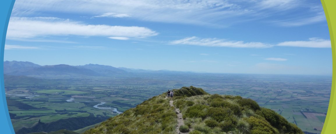
Little Mt Peel/Huatekerekere
| Distance: | 4-6 hours return |
| Classification: |
Tramping Track |
| About the walk: | Begin as for Deer Spur and continue on beyond the tarn, joining the main ridge and following it to the summit (1311 m). On a clear day the views extend to Mt Somers, Mt Hutt and across the plains to the coast. The Tristram Harper Memorial Shelter is just below the summit. |
South Ridge Route
| Classification: |
Route |
| About the walk: | A steep descent off little Mt Peel may be made by experienced trampers or climbers taking the main ridge behind the shelter. Keep strictly to the ridge until a track sign directs left, down a tussock-covered spur to the bush line. Then zigzag steeply until emerging into Emily Stream just above Emily Falls. |
Collect a DOC Peel Forest Park brochure from the Methven i-SITE Visitor Centre.
View My Planner
New Zealand
Phone: +64 3 302 81725 | Fax: +64 3 302 8954
![]()
Free advice from travellers for a great Methven vacation.