Rangitata River
The Rangitata River, 75 miles in length, reaches the sea just north of Temuka and is formed by the confluence of two main tributaries, the Clyde and Havelock Rivers, which with their tributaries drain the eastern side of the Southern Alps from the Lyell Glacier to the Godley Glacier.
HOW TO GET HERE
ABOUT THE RIVER
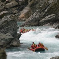 The Rangitata River is known for its spectacular gorge made world famous for the exciting and challenging rafting trip run by Rangitata Rafts. It is also a popular fishing river with salmon, brown and rainbow trout. The fish spawn in many crystal clear, spring fed streams in the headwaters. The gravel riverbeds are the nesting habitat for four endangered native birds - Wrybill, Banded dotterel, Black-fronted tern and the Black-billed gull. The three main tributaries (Havelock, Clyde and Lawrence) provide access for tramping and mountaineering in the Southern Alps.
Other large tributaries are the Lawrence River, which drains the west side of the Arrowsmith Range, and Forest and Bush Streams, draining part of the Two Thumbs Range, and Potts River. These larger tributaries join the Rangitata in the large glacially excavated basin containing several sheep stations, including Mesopotamia Station, where Samuel Butler established himself in the early sixties.
Search Methven
Trip Planner
View My Planner