A variety of easy walks around Lake Coleridge Village and longer day and multi-day hikes on public tracks in the Lake Coleridge basin.
There are a range of easy walks around the Lake Coleridge Village (including an historic walk with self guided walking notes and map) to longer day and multi-day hikes on public tracks in the Lake Coleridge basin.
Lake Coleridge Village Historial Walk
| Distance: | 30 mins - 2 hours return |
| Classification: | Easy |
| About the walk: | Walk the many village paths and learn about the area’s history. Lake Coleridge Village was built around New Zealand’s first state-owned hydroelectric power station, which was constructed between 1911 and 1914. |
Hart Arboretum Walk
| Distance: | 30 mins - 2 hours return |
| Classification: | Easy to moderate |
| About the walk: | Walk the many village paths and learn about the area’s history. Lake Coleridge Village was built around New Zealand’s first state-owned hydroelectric power station, which was constructed between 1911 and 1914. |
Lake Ida
| Distance: | Lake Ida - 2 hours return. Lake Catherine/Monck - 4 hours return |
| Classification: | Moderate |
| About the walk: | The entrance to this track is about 30 minutes’ drive from Lake Coleridge Village on Harper Road. Between Lakes Evelyn and Selfe you’ll find a small car park. Orange posts mark this track, which is still being developed by the Department of Conservation. Follow the markers along the fence line and then look up the hill to find the next marker. The track takes you through low-growing alpine plants to a lake shaded by towering Mt Ida, causing it to often freeze over in winter. The track can also be icy in parts during winter. When you reach the lake take note of where you exit the path so you can find the track again to return home. You can explore the lake shore and look for trout. Near the now disused lakeside chalet, the orange posts continue onto Lake Catherine/ Monck (another 45 mins to 1 hour). The track to Lake Catherine/Monck is less well formed and crosses some swampy areas and river tributaries. |
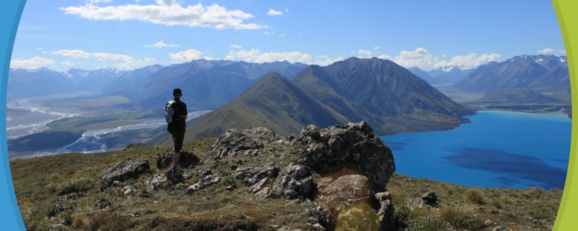
Peak Hill
| Distance: | 3 - 4 hours return |
| Classification: | Hard |
| About the walk: | If you’re after spectacular views of the whole area this is the walk for you! The entrance is about 10 minutes’ drive from Lake Coleridge Village. The walk involves a steep uphill climb to the summit where you get 360° views of Lake Coleridge, the Southern Alps and the Rakaia and Wilberforce river systems. The return walk involves descending steep sections so good shoes and reasonable fitness are a must. |
Dry Acheron Track
| Distance: | 2 - 10 hours return |
| Classification: | Moderate |
| About the walk: | This track begins about 10km before you reach Lake Coleridge Village. You follow orange markers across high country farmland criss-crossing the Dry Acheron stream, with side tracks taking you to two developing bush covenants. The second half of the main track, which begins about 2 hours in at the junction with the track to Conical Knoll Covenant, climbs Big Ben and is only recommended for people with a high level of high-country skills and experience. |
Collect a Walks in the Lake Coleridge Area map from the Methven i-SITE Visitor Centre.
View My Planner
New Zealand
Phone: +64 3 302 81725 | Fax: +64 3 302 8954
![]()
Free advice from travellers for a great Methven vacation.